News:
Connecticut
Posted: September 18, 2007
GIS technology helps developers deliver on the promise of better, faster and cheaper
Few technologies have delivered on the promise of "better, faster, cheaper", more so than the application of GIS to land development. A mere decade ago, some civil engineering consultants struggled to decipher what the letters stood for; today its ubiquitous utilization in our industry makes GIS one of the most used clubs in the consultant's bag.
GIS 101
ESRI, the creator of the de facto industry standard software, defines a GIS as "…a collection of computer hardware, software, and geographic data for capturing, managing, analyzing, and displaying all forms of geographically referenced information." In simplified terms, GIS is the natural combination of mapping, database, and modeling technologies into a single, extremely powerful tool.
People are generally spatial thinkers and tend to consider issues geographically when making decisions. We evaluate the availability of natural resources, the condition and quality of infrastructure, the driving market forces, and the constraints to development based upon a site's location. GIS provides us with a tool to better organize and understand location-relevant information and thereby allows us to make better, more-informed decisions.
GIS in Land Development
We've all heard that the three most important things in real estate are location, location, and location. ESRI estimates that approximately 80% of all business data has a spatial, location based component. Some examples include regional trends in property sales, locations of customers and clients, land inventory, and market demographics.
We also know that that the commercial real estate market is fiercely competitive and the ability to make expert, well informed decisions faster than your competition is critical to one's success in this environment. As a result of its ability to display and model geographic data in an intuitive manner, GIS has become an excellent tool for gaining that competitive advantage. The visual nature of data modeling and analyses presented in a map format can reveal trends, patterns, and opportunities that cannot be readily detected from tabular data.
Site Selection and Strategic Planning - At Tighe & Bond, we routinely combine available public data sets (e.g. orthophotography; hypsography; traffic data and road networks; zoning, land use, conservation, and open space maps; hydrography and watershed information; and census data) with both owner supplied and field collected data (e.g. infrastructure mapping and asset management; detailed planimetrics and topography; etc.) to identify the ideal location for a new facility or to select the right location for expansion of existing facilities.
Development and Constraint Analyses - Similarly, once a site has been selected or a short list of alternatives developed, we can dig deeper by utilizing other data sets(e.g. environmental risk sources; mapped wetland resources, certified vernal pools, and natural heritage priority habitat; surficial soils, site geology, and aquifer mapping; etc.) and then overlaying other design constraints such as zoning setbacks and other physical limitations from existing buildout, to create a "developable envelope" map. With proper analysis of the site constraints owners, developers, and real estate investors can better select the site with the lowest site permitting and development cost and identify the site with the potential for the greatest return on investment.
The Next Wave - Geo-Based Design Movement
ESRI and the GIS development community are now exploring the concept of life cycle real estate management, a market distinguishing characteristic of GIS. Only GIS affords users the ability to look at a parcel or tract of land from the global to the interior asset management point of view and also manage them over time.
This four dimensional capability and "zoomability" (i.e. in space and time) gives developers, consultants, and planners a cockpit from which to see their enterprise in context - geographically and temporally - and zoom into the time andplace where critical events are happening. Users will be able to identify and analyze the elements necessary to support successful decisions. Key elements might include:
* Regional and local conservation planning for raw land
* Real estate market analyses
* Field survey data
* Utility modeling and analyses
* Viewshed analyses
* Low impact civil/site/landscape design, including carbon offsets
* Construction management
* Facility management
* Asset management (including BIM and CAFM) with linkage to asset management sensors
* Recycling/re-use/repurpose analyses.
My colleague, Terry Martin at ESRI, is convinced that "we are at the dawn of a new age of GIS, where one can go from a global point of view to an individual asset point of view and trace it through time. The implications for landowners, developers, managers, and planners are truly impressive".
Fran Hoey is senior vice president and director of real estate development at Tighe & Bond, headquartered in Westfield, Mass.
Tags:
Connecticut
MORE FROM Connecticut
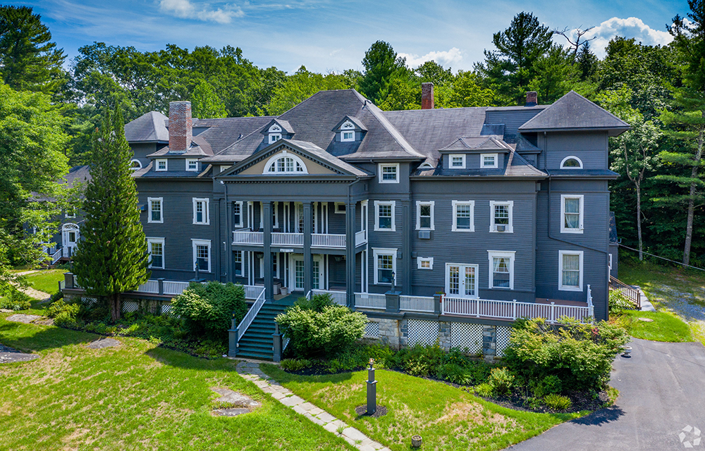
Galton of Houlihan Lawrence sells 15,800 s/f Wake Robin Inn for $3.5m
Lakeville, CT Houlihan Lawrence Commercial, a division of Houlihan Lawrence, a real estate firm serving Connecticut and New York City’s northern suburbs, has brokered the sale for $3.5 million of the Wake Robin Inn, a 15,800 s/f historic inn located on 11.52 acres at 106 Sharon Rd.