News:
Rhode Island
Posted: February 14, 2020
City of Providence unveils final Great Streets plan
Providence, RI In the Woonasquatucket Corridor, mayor Jorge Elorza joined councilwoman Rachel Miller, director of Planning and Development Bonnie Nickerson, and community partners and advocates to announce the release of the City of Providence’s Great Streets Initiative and Urban Trail Network Master Plan (Great Streets).
“We are committed to providing our community with streets that support our growing population and economy,” said Elorza. “Great Streets equips Providence with a roadmap that better connects our community and creates an inclusive city that meets the needs of all residents and visitors to the Capital City, no matter how they choose to get around.”
Following a year-long, robust community engagement process, Great Streets establishes a framework for public space improvements to ensure that every street in Providence is safe, equitable and sustainable. Informed by insights generated from thorough analysis of crash data, traffic calming requests, and housing and transportation figures, the plan outlines a bold vision for the future of Providence’s largest public asset, its streets.
Covering over 13% of Providence’s total land area (over 1,500 acres), streets play a central part in our neighborhoods. A key strategy outlined in the plan is reducing household transportation costs by making it more convenient for people to use and access affordable transportation options such as walking, riding bicycles, and public transit. Other goals include improving traffic safety and personal safety within the public realm for people of all ages, abilities, and economic statuses, lowering greenhouse gas emissions, and improving public health. According to the World Health Organization’s 2018 Global Status on Road Safety report, traffic-related crashes are the number one cause of death in children and young adults aged five to twenty-nine.
“As a 21st Century city, we need infrastructure that improves the quality of life for all residents,” said Miller (Ward 13). “We need safer streets for pedestrians, cyclists, and motorists alike and I believe this plan accomplishes that lofty goal. I commend the planning department and all that took part in crafting this important and thoughtful approach to making our neighborhoods safer. As the councilor who represents the Federal Hill area, I am all too aware of how traffic calming initiatives are needed there. I am very happy that several of our streets on the Hill will be addressed through this comprehensive plan.”
The plan complements the work of ongoing infrastructure projects outlined in the City’s FY2020-FY2024 Capital Improvement Plan (CIP), signed by the mayor earlier this month. Over the next five years, the CIP identifies nearly a $25 million investment in Great Street initiatives. These improvements include streetscape and placemaking projects, safety improvements to make streets and intersections safer for people walking and riding bicycles, traffic calming to reduce speeding and cut through traffic, and the creation of a “spine” network of Urban Trails that connect every Providence neighborhood.
“Great Streets rebalances the public space of our streets to meet the needs of all residents in our City,” said Nickerson. “It’s a new approach to how we invest in Providence that will have a long-term impact on safety, equity and resilience.”
These improvements will bring 93% of residents and 95% of jobs within easy walking distance of the Urban Trail Network. This is a significant increase compared to the 21% of residents and 37% of jobs within easy walking distance of the existing network. Urban trails are on or off-street paths that are safe, comfortable, and easily accessible for people of all ages and abilities. On busy streets, Urban Trails are fully separated from vehicle traffic. In other instances, off-road trails and paths like the Blackstone Bike Path and the Woonasquatucket River Greenway serve as part of the Urban Trail Network.
In June, the City of Providence distributed a draft version of the Great Streets plan. As part of the release, the community was invited to view recommendations for projects in an online interactive map. The City integrated the additional community feedback ahead of the final plan release.
The Great Streets plan—including a map of the Urban Trail Network—can be downloaded at http://www.providenceri.gov/planning/great-streets/. On the website you can stay up to date on the plan’s progress and view a list of upcoming construction projects and public engagements.
Tags:
Rhode Island
MORE FROM Rhode Island
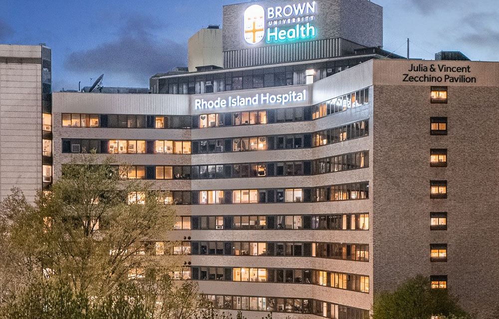
JLL to oversee 4.5 million s/f Brown University Health real estate portfolio
Providence, RI JLL has been selected by Brown University Health (BUH) in Rhode Island to support the oversight and management of its combined Brown University Health real estate portfolio.


Quick Hits