News:
Connecticut
Posted: August 13, 2008
Floodplain facts and fallacies: A better understanding of floodplain management
Living and working in the Northeast and Mid-Atlantic regions, we are bounded by the floodplains of rivers and their many tributaries. To assist in better understanding the oft-misunderstood regulatory framework surrounding floodplain management, I have compiled the following floodplain facts.
Floodplain management is a Federal Emergency Management Agency (FEMA) program, administered at the local level. It consists of the operation of a community program of corrective and preventative measures for reducing flood damage. These measures take a variety of forms and generally include requirements for zoning, subdivision or building, and special-purpose floodplain ordinances. The community is responsible to review and maintain record of the documentation demonstrating that any permitted floodway encroachment meets National Flood Insurance Program (NFIP) requirements.
The terms "100-year flood" or "100-year floodplain" may be misleading. The 100-year flood is not a flood that will occur once every 100 years. Rather, it is the probability that a given flood elevation has a 1% chance of being equaled or exceeded each year. Thus, the 100-year flood could hypothetically occur multiple times over a relatively short period of time. The 100-year flood, which is the standard used by most federal and state agencies, is used by the NFIP as the standard for floodplain management and to determine the need for flood insurance. Based upon this probability calculation, a structure located within a 100-year floodplain or other special flood hazard area shown on an NFIP map has a 26% chance of suffering flood damage during the term of a 30-year mortgage.
A "Regulatory Floodway" means the channel of a river or other watercourse and the adjacent land areas that must be reserved in order to discharge the base flood without cumulatively increasing the water surface elevation more than a designated height. Communities must regulate development in these floodways to ensure that there are no increases in upstream flood elevations. For streams and other watercourses where FEMA has provided Base Flood Elevations (BFEs) but no floodway has been designated, the community must review floodplain development on a case-by-case basis to either ensure that increases in water surface elevations do not occur, or identify the need to adopt a floodway if adequate information is available.
Rivers and streams where FEMA has prepared detailed engineering studies may have designated floodways. For most waterways, the floodway is where the water is likely to be deepest and fastest. It is the area of the floodplain that should be reserved (kept free of obstructions) to allow floodwaters to move downstream. Encroaching upon a floodway may block the flow of water and increase flood heights. Because of this, your community will require that you submit engineering analyses before it approves permits for development in the floodway.
Encroachments are activities or construction within the floodway including fill, new construction, substantial improvements, and other development. These activities are prohibited within the adopted regulatory floodway unless it has been demonstrated through hydrologic and hydraulic analyses that the proposed encroachment would not result in any increase in flood levels. If your lot or building site is on natural ground that is higher than the base flood elevation (BFE) shown on the Flood Insurance Rate Mapping (FIRM), then you may request a Letter of Map Amendment (LOMA). To support your request, you will need a surveyor to determine the elevation of the ground next to your structure and complete an Elevation Certificate. If the ground is higher than the BFE, then FEMA will issue a LOMA. With a LOMA your lender may choose not to require flood insurance.
If your structure was built on fill that was placed after the FIRM was prepared, you may request a Letter of Map Revision Based on Fill (LOMR-F). As with a LOMA, you will need an Elevation Certificate completed by a land surveyor. If the filled ground is higher than the BFE and the structure does not have a basement, then FEMA may issue a LOMR-F, and your lender may choose to not require flood insurance.
In short, new construction, or modification to an existing structure, is often permissible within the 100-year floodplain, providing certain conditions are met. New construction, or modification to an existing structure within the regulated floodway is usually not permitted. It is the responsibility of the property owner to know the floodplain status of a property, and be aware that it can drastically affect the marketability or development viability of the property. As with any regulatory program, to fully understand the floodplain requirements of a particular property, it is recommended that the local municipality floodplain management official be consulted.
James Kodlick, CE, PWS, RPA, is a principal of BL Companies and the manager of the environmental resources group, Meriden, Conn.
Tags:
Connecticut
MORE FROM Connecticut
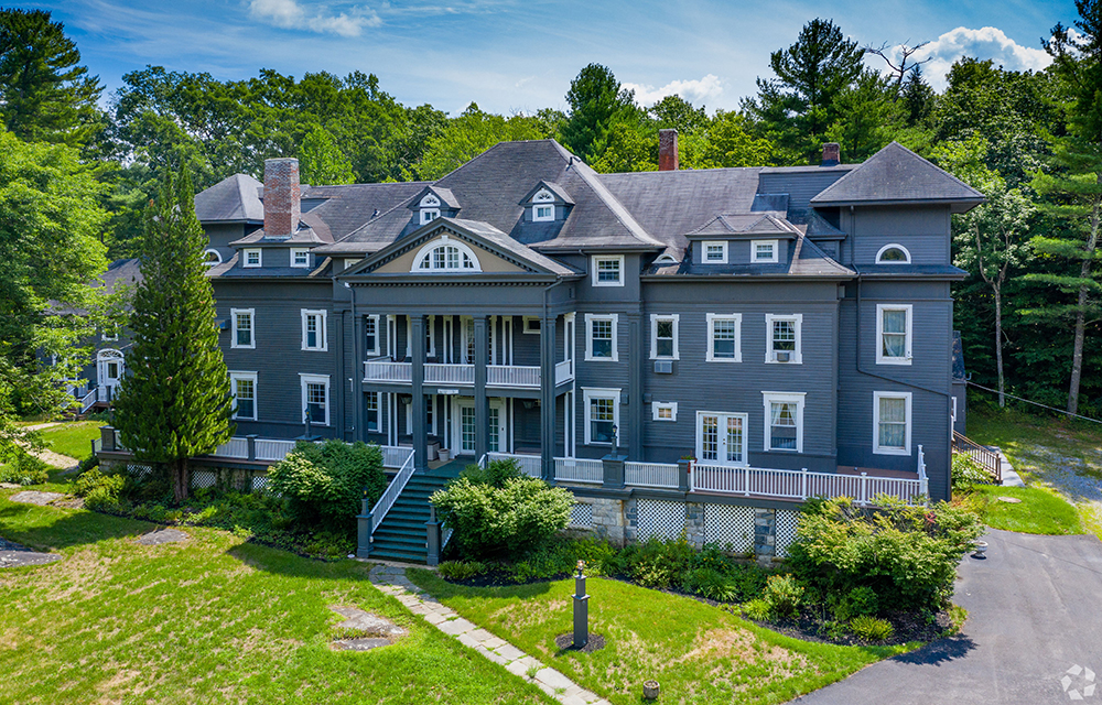
Galton of Houlihan Lawrence sells 15,800 s/f Wake Robin Inn for $3.5m
Lakeville, CT Houlihan Lawrence Commercial, a division of Houlihan Lawrence, a real estate firm serving Connecticut and New York City’s northern suburbs, has brokered the sale for $3.5 million of the Wake Robin Inn, a 15,800 s/f historic inn located on 11.52 acres at 106 Sharon Rd.