News:
Connecticut
Posted: February 17, 2011
Land is the hardest type of property to appraise
By Robert Stewart, SRA
Ever wonder why some appraisers just cannot seem to properly appraise land? Appraising land is a much different than appraising a typical house or a commercial property. When appraising a house, you make adjustments for differing bathrooms, size, quality and such amenities as fireplaces or garages. When appraising a commercial building you may be looking at zoning, use, ceiling height, amount of finish, and various ratios. When appraising land, the easiest way to summarize value is - what can you do with it? In other words, if it is all swamp land and all you can do is play with alligators, the value is much lower than level land that is easily developable or easy to subdivide into multiple building lots.
When analyzing and valuing land, the highest and best use is the most important factor. Highest and Best Use is that use that is physically possible, legally possible, economically feasible, and indicates the highest value of the property. Therefore, when valuing land and determining the highest and best use, the first thing you do is look at what is physically possible. Limitations on this include the topography, zoning, soil types, including inland wetland soils, and utilities available or needed. Looking at zoning first, is the zone appropriate for the area or is a zone change possible? In an area that is changing from rural to a more intense development, a zone change to allow more lots per acre or even multi-family or commercial use may be possible. However you also need to analyze the demand for the uses that are possible. After narrowing your list from any use, to those uses that are permissible by zoning, you need to apply the minimum lot size and other restrictions in the Town Zoning and Subdivision Regulations. In addition, the soil characteristics need to be analyzed at a minimum in regard to inland wetlands and, if septic systems are required, the ability of the land to support septic systems. In regard to residential subdivision, many towns are now basing approvals on density as well as minimum lot size and they may also have a required buildable area. The buildable area has a minimum size and often shape and restrictions on what land can be included. This can significantly restrict the number of building lots with an abnormal shaped parcel or one with some steep slopes or inland wetlands or easements, etc.
A common problem with a parcel of a significant size, is figuring out the boundaries and total size. Having a survey is most advantageous, though often a survey has not been completed. The next best source is the deed, however, with older deeds there usually are no specific metes and bounds, only mentions of bounds by land of others, or a road, brook, or river with no dimensions. When this is the case, you usually have to rely on the Assessor's maps. But, they state right on them "For tax purposes only and not for legal reference". One issue that I have encountered on many occasions is when the property is on more than one Assessor's map, the boundaries do not necessarily line up when you put the two maps together. Further, with large parcels, there may not be a dimension listed that could scale to a different dimension stated or in the deed. This makes the Assessor's map a starting point. With the map you can look for dimensions in deeds or on surveys of the abutting properties. Hopefully with these, you can establish the subject boundaries. Often you need to look at the US Geological Survey topography maps or any other map available and use physical characteristics. With all this work you hopefully have an idea of the shape and size of the subject parcel and can go walk the property. A great resource is the owner or someone who knows the site who can help point out boundaries that you can identify on a topography map.
Now that you have the shape of the site and may have walked it, you need to determine the soil characteristics. The soil classifications of properties can be found by going to USDA Natural Resources Conservation Service Web Soil Survey website which is: http://websoilsurvey.nrcs.usda.gov/app/HomePage.htm. Using this website could be an article in itself, but basically following the directions, you can locate the subject, choose the area of interest (subject), and then identify the soil classifications. This website also has descriptions of each soil classification as to farmland and development capacity and characteristics.
With all this data, the appraiser can determine (sometimes guesstimate) the site's highest and best use. Now that you have the subject property's highest and best use, you need to locate comparable sales to compare to the subject so you can value it. Not only do you need to know the subject's highest and best use, you need to know the highest and best use of each comparable. That is, on what basis did this buyer and seller establish their purchase price. Then you can compare and adjust each comparable to the subject resulting in an indicated value.
If this sounds complicated and confusing, that is because it is. This is why land is the hardest type of property to appraise and you need to be sure you have an educated and qualified appraiser. Contact the Appraisal Institute if you need just such an appraiser.
Robert Stewart holds the SRA designation from the Appraisal Institute. He owns and has operated Stewart Appraisal Services in Tolland, Conn. since 1981. His work includes specializing in valuing land throughout northeastern Connecticut.
Tags:
Connecticut
MORE FROM Connecticut
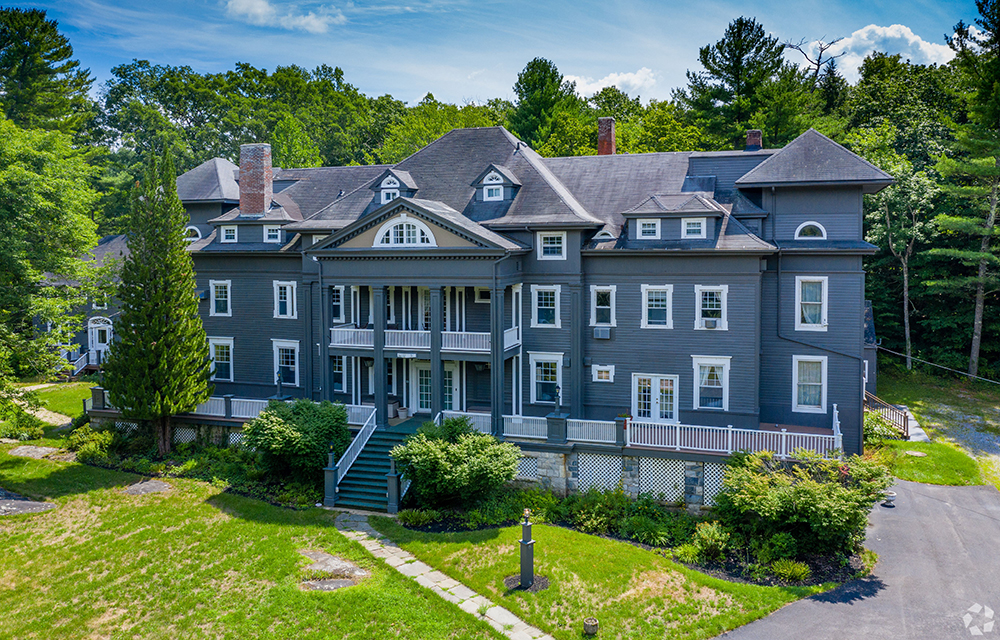
Galton of Houlihan Lawrence sells 15,800 s/f Wake Robin Inn for $3.5m
Lakeville, CT Houlihan Lawrence Commercial, a division of Houlihan Lawrence, a real estate firm serving Connecticut and New York City’s northern suburbs, has brokered the sale for $3.5 million of the Wake Robin Inn, a 15,800 s/f historic inn located on 11.52 acres at 106 Sharon Rd.