News:
Rhode Island
Posted: September 12, 2007
Master plan creates identity for Newport's North End
This year, the Newport city council is expected to vote on a master plan that will create a new identity for the city's North End. The master plan calls for development of the area into a cohesive and well-functioning mixed-use community that will benefit all of Newport.
Currently, the North End is a splintered area that includes Newport Heights, an exemplary new affordable housing development; the Malbone Rd. neighborhood, which consists of longstanding, single-family homes; the Prescott Hall neighborhood also with single-family homes;, and to the west, affordable multi-family housing and Naval Station Newport. Also included in the North End are the former U.S. Naval Hospital, on a 10-acre waterfront site that the U.S. Navy is considering disposing of, and the Newport Grand, a 24 acre video gaming venue whose site is underdeveloped. All of these areas surround a commercial strip on J.T. Connell Highway and industrial and vacant land in the center of the North End.
PB was engaged by the city in November 2005 to prepare a new master plan that would set the stage for economic redevelopment of the area. The goal was to provide a decision-making guide for future development.
Newport's planning board unanimously approved the master plan in its entirety in January 2007, following a series of presentations and community meetings attended by area stakeholders. The planning strategy is based on creatively using planned public infrastructure investments and potential land development opportunities in the North End to benefit the entire city.
In order for the plan to come together, the city has asked the RI Department of Transportation (RIDOT) to reconfigure the Pell Bridge interchange to improve access, open up additional land for development, and create a "gateway" to Newport (Rte. 138). Originally, prior plans called for a four-lane highway to cross Aquidneck Island. The interchange was built to accommodate the highway, but the highway was never built.
An embankment for a ramp and a bridge were also built over Admiral Kalbfus Rd. to connect to the highway. The city wants the ramp and bridge demolished and the land used to open approximately 31 acres for economic redevelopment.
The reconfigured interchange site is to be divided into a north and south parcel on either side of Admiral Kalbfus Rd. The 19 acre south parcel would contain up to 250,000 s/f of retail space; 150-250 apartments (condominiums or rentals) above the stores; up to 65,000 s/f of office space; 1,300 to 1,800 parking spaces in garages and at-grade; a transit center next to the Newport Secondary Railroad tracks which are used for tourist trains, with a planned rail shuttle between downtown Newport and an existing marina in Portsmouth that is currently being expanded to 1,500 slips; and a pedestrian bridge across the railroad tracks to connect the waterfront with the new shopping center and mixed use village.
Recommendations for the 12 acre north parcel include a 125,000+ s/f indoor recreation center or an indoor water park and hotel along with 175-220 at-grade parking spaces.
Adjacent to this interchange property is the Newport Grand. The state wants to double the number of video gaming machines if the venue owner will add $20 million in improvements that also will include a 90-room, seven-story hotel. At the 10 acre former Naval Hospital site, the plan calls for construction of 100 high-end condominium units, a 100-room boutique hotel, 250 at-grade parking spaces, and a waterfront park with a water shuttle dock at the existing concrete pier. This site will also contain a marina and a 1,000-foot walkway/bikeway from Third Street to Washington St. situated along the northern and waterside edges of the property.
Other sites in the North End include a five-acre parcel acquired by the city from RIDOT to expand businesses development. In addition, there are three older school buildings that may be sold, renovated or demolished with one new elementary school in the North End built to replace them. The master plan recommends improvements to Miantonomi and Sunset Hills Parks, together the largest open space in Newport.
Plans also call for upgrading a drainage ditch in the interchange parcel and transforming it into a canal as an amenity for the mixed-use retail village. The construction of the canal will also solve a flooding and drainage problem. To alleviate traffic congestion in the area, the master plan recommends construction of a new half-mile long, four-lane road behind the existing Newport Towne Center (retail) that will connect Admiral Kalbfus Rd. with the J.T. Connell Highway.
The master plan includes an implementation strategy to coordinate all of the sites within a single 10-year development program. It is projected that the city will receive $1.7 million in property tax revenues and 1,200 permanent jobs will be created from the three major development parcels alone.
Before redevelopment on the North End can begin, the city council must vote on the master plan. Next, RIDOT must move ahead with reconfiguration of the Pell Bridge interchange. This will be followed by the city acquiring the remaining parcels from RIDOT and the waterfront parcel from the Navy.
The next step will be for the city to advertise the availability of parcels for redevelopment, respond to developers, and then proceed with the development process. The city will also rezone these parcels for the proposed development projects.
Allan Hodges, FAICP, is a lead technical planner, New England region, PB, Boston.
Tags:
Rhode Island
MORE FROM Rhode Island
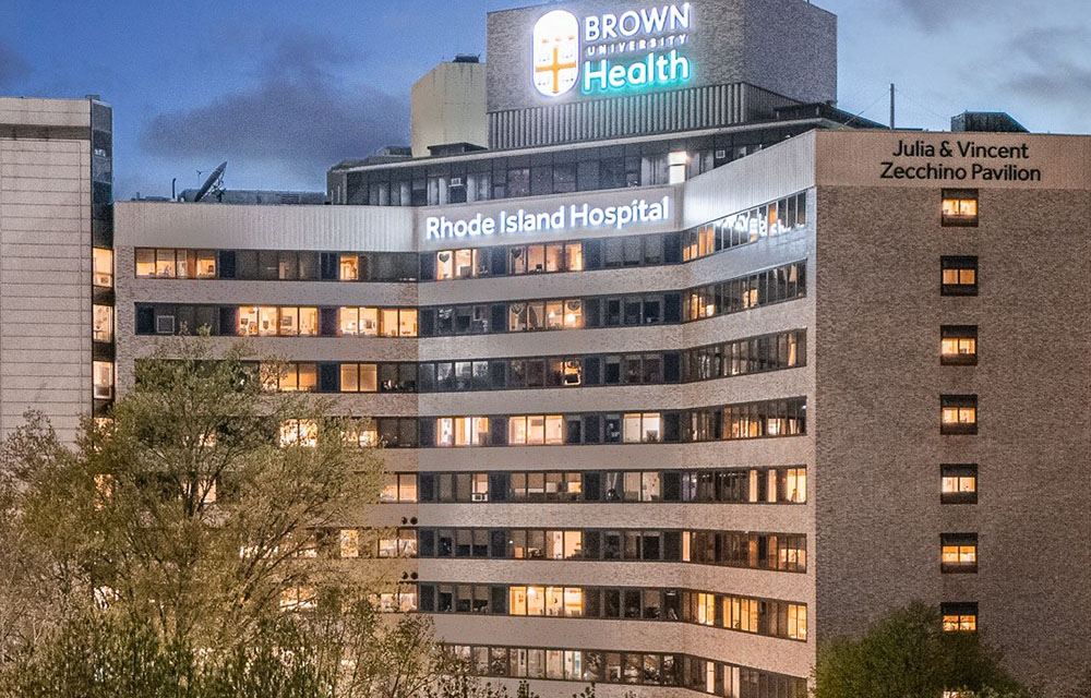
JLL to oversee 4.5 million s/f Brown University Health real estate portfolio
Providence, RI JLL has been selected by Brown University Health (BUH) in Rhode Island to support the oversight and management of its combined Brown University Health real estate portfolio.


Quick Hits