News:
Connecticut
Posted: September 15, 2011
Visualization - New technology offers new opportunities
In the early 1800s, Humphrey Repton pioneered a technique that enabled him to show his clients how his proposed design work would change what they currently see. He put his "Before and After Pictures" in a book form with a red cover. These came to be known as " Repton's Redbooks". These sketches allowed him to communicate his design ideas to people who could not read plans. In the 1970s, the federal government and the American Society of Landscape Architects developed guidelines and procedures to determine how visual resources would change due to construction of buildings and roads. This process established a level of certainty that the drawing produced could be considered "accurate" and not just artist's rendering. Over the next 20 years, this technique was expanded, enhanced and defined by landscape architects and reviewing agencies to ensure that, if the procedures were followed, two consultants would get the same results; thereby, providing authenticity.
These visualization techniques worked very well when combined with professional training. New procedures were established every time new technologies created better opportunities for accuracy. In the 1970s photographs were taken and projected on a wall and traced. Then access to larger photos allowed drawing onto those photos directly. Most recently, the digitalization of photos allows us to set the proposed conditions directly into the photographs provided that horizontal and vertical markers are provided. This creates a very realistic looking image to show the client, public, or agency.
Recent technology upgrades have begun to infiltrate into the public forum - Google's Sketch-Up and other similar programs allow even an amateur to create a 3-dimensional view of a building. For the most part, these computer modeling programs allow for the manipulation of volumes and walls in a manner not previously available without the use of perspective charts, but there is some peril in using this new technology without the proper safeguards. Without a true understanding of architecture - the textures, materials, sizes, walls and building facades, the roof lines and edges - the building rendering remains flat and awkward and most likely just wrong.
In addition, when adding the Sketch-Up model into a photograph, the model has no vertical or horizontal guide markers to ensure that the scale or perspective is correct. For that reason, most building renderings continue to look like a computer model with fake sky on a flat site or like a foreign object was pasted into a photograph.
Even with the new tools available, if you are looking for an accurate, reliable representation of how the landscape will look where you want to add a building, road, parking, signs, etc., you must still use those defined procedures from the 1970s. The first thing you need is someone trained in visualization. The training of a landscape architect, in particular, is specifically designed to provide the professional with the necessary skills to be able to understand how a viewpoint will change. Next, you need a professional who understands the industry (and court) accepted methodology to create these images. Depending on how they are to be used, these images often require a professional to stand behind the drawing. They are not just an artist's rendering or best guess. Instead, they are the professional's best technical and aesthetic interpretation of what will be.
The third element which is required for the professional to be able to work is defined horizontal and vertical landmarks. Photographs should be taken with a plan in hand so that specific elements and elevations are anchored on the map, or better yet, survey. Without this third element, it is anyone's guess as to where something fits in the landscape. Typically, if you are preparing a 'before and after' set of drawings, the public or regulating board expects that the person preparing these know what they are doing and that they are accurate. This is important because many land use decisions are based on these images and if they were not accurate then the approving agency will feel deceived, at best, or will, potentially, nullify your approval.
The new technology available for 3-D images is truly amazing. But it takes the same skills to make these images true and accurate as it did in the "old" days when slide projectors were used. The technology should be lauded for its capabilities, but it is the design and graphic skills and professional integrity of the operator that makes an image a true "vision of the future".
Terri-Ann Hahn, ASLA, CPESC, CPSWQ, LEED AP is a principal of LADA, P.C. - Land Planners, Simsbury, Conn.
Tags:
Connecticut
MORE FROM Connecticut
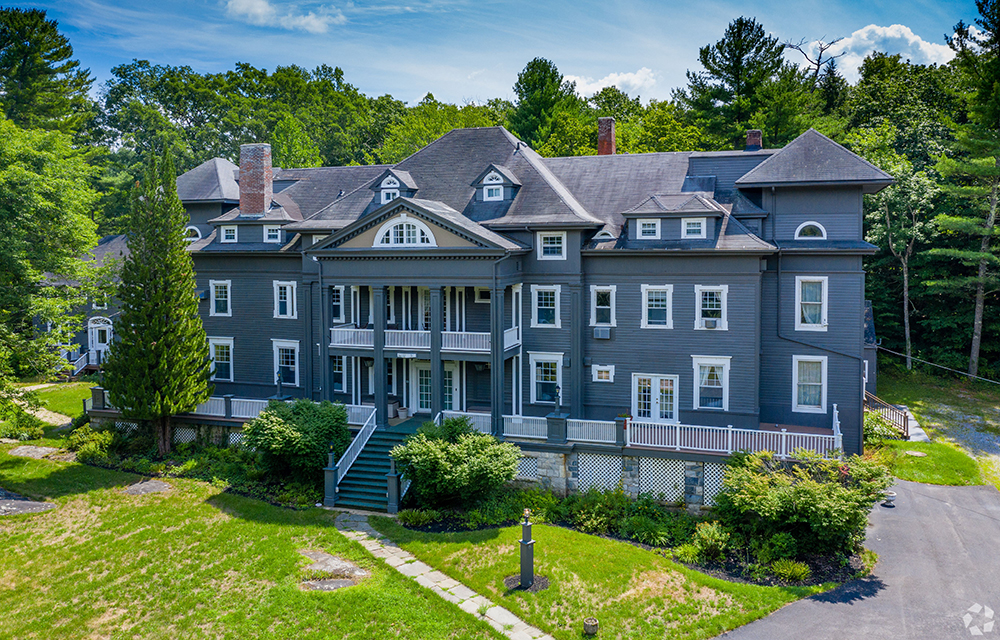
Galton of Houlihan Lawrence sells 15,800 s/f Wake Robin Inn for $3.5m
Lakeville, CT Houlihan Lawrence Commercial, a division of Houlihan Lawrence, a real estate firm serving Connecticut and New York City’s northern suburbs, has brokered the sale for $3.5 million of the Wake Robin Inn, a 15,800 s/f historic inn located on 11.52 acres at 106 Sharon Rd.


Quick Hits