News:
Connecticut
Posted: October 14, 2009
Conn. Chapter of Appraisal Institute holds soil seminar
Tuesday, September 9, the Connecticut Chapter of the Appraisal Institute posted a seminar at their annual meeting presented by Shawn McVey, assistant state soil scientist regarding the history, purpose and the new web based soil survey from the NRCS, which is National Resource Conservation Service, formerly known as the Soil Conservation Service as an agency of the USCA. Also presenting was appraiser Thomas Henry, MAI, an appraiser of conservation easements and user of the web based soil survey. McVey explained that the soil conservation service was created during the dust bowl back in the 1930s. Currently, NRCS has 11,000 employees and maintains a presence in local county and multi-county levels nationwide, as well as in the Pacific and in the Caribbean.
Back in the 1930s the programs NRCS undertook were primarily driven by government interests, particularly with the Civilian Conservation Corps (CCC) Camps set up as part of President Franklin D. Roosevelt's New Deal to help end the Great Depression (1933-1942). The initial projects involved forest conservation work, road work, flood control efforts and the starting of agricultural oriented experiment stations. In the late 1930s a change occurred. The then director, M. L. Wilson, under the Secretary of State, chose to make the program more grass roots oriented by initiating soil conservation district offices that would be supported by local farmers allowing the farmer to benefit from better management practices for their land. Through a whole farm management system, through disciplinary assistance and a practical approach to watershed, farmers were now able to get support to increase yields while at the same time start programs to preserve land.
The NRCS continues to develop and provide technical schools and support for this purpose, as well as financial assistance through cost sharing, easements and stewardship payments. The most recent tool provided is the digital soil survey, which is a national survey of soils classified in a standard system. The State of Connecticut NRCS completed their survey by July 15, 2005, making them one of the leading states in the country for this new program. Connecticut was fortunate because the first soil survey was conducted in the Connecticut Valley in 1899. NRCS was able to use this information as a base to incorporate the older soil classifications (previously different not just from state to state, but different from one part of Connecticut to another) into the new national standard classification system. The seminar hosted by the Connecticut Chapter of the Appraisal Institute provided a useful overview to help appraisers capitalize on this tool in their valuation analysis.
The web soil survey creates maps online and provides for access to the soil surveys throughout the country. Not all states are as developed as the State of Connecticut, which is fully developed, providing all the resources necessary to support the new survey. The web soil survey replaces all the old individual soil books that had previously been used to understand soil make-ups for each county. The old books are not considered obsolete as the soil symbols have been reclassified and consolidated to eliminate the overlap of similar soils having different names in different counties. The soil survey is available to anyone on the web at www.soils.usda.gov/survey .
McVey went on to discuss the different types of soils that are important to urban development, as well as agricultural use. How the soil profiles are identified and used to determine the soils use, and also how the soil surveys from one period to another are used to identify changes in land use and urban development. Using as an example of showing the Buckland Mall site in 1940, which was entirely agricultural use back then, and comparing it to a 1995 pictures showing the development with a commercial use. The maps allow appraisers to better understand the physical attributes of soils supporting improvements as well as the potential utility of land, particularly larger undeveloped parcels.
Using the same maps, McVey showed the mapping system that can be found on the website. He then went on to explain how the system is used in land planning and how the website provides not only the mapping and the soil identification, but a means to identify wetland soils along with their definitions and explanations. He showed how to navigate the program once the property is identified by the property address and then to determine what physical features, such as road names, municipalities, government, boundaries and other types of map symbols can be incorporated into a map display. Available, once the map area is identified, the background can be changed to reveal a topographic map. Also, once the area is identified, a number of soil capabilities can be identified for each soil type to assist the appraiser in identifying building/development potential, habitat ability, land that could be allocated for open space/forest land; nearly any type of land use is supported and explained.
Eligibility of the programs provided by the NRCS is based on the soil class classifications, primarily prime and state wide important farmland soils. This has been extended to locally important soils now available in six Connecticut towns. Soils that were not typically important farmland soils, but have become important in local areas as they may be at the lower end of the range, are also separately classified. These edge land soils have been cleared, de-rocked and are in active use in certain communities making local important farmland soils. Consequently, these areas can now easily be identified in order to allow local communities to be eligible for various NRCS programs they may have had difficulty proving criteria to participate in before. Soil interpretive maps can be selected and there are 250 major interpretive options for the Connecticut users of the web soil service. These can be selected on the browser to develop reports for determination of the soils property capabilities, which among them include suitability for basements, subsurface sewage disposal systems, and a variety of other purposes.
The current focus for the NRCS is for the protection of farmland, grasslands and wetlands. They have three programs that use conservation easements to protect these types of soils. The new web based soil survey is becoming a great tool to help appraisers value these conservation easements, as well as remaining development rights. The Wetlands Reserve Program and the Grasslands Reserve Program are used to protect sensitive areas and locals habitats. The FRPP, Farmland and Ranch Land Protection Program, is to protect agriculturally productive lands.This area is of particular interest to appraisers and users.
Thomas Henry, MAI is with T. W. Henry Real Estate Appraisals, East Granby, Conn.
Tags:
Connecticut
MORE FROM Connecticut
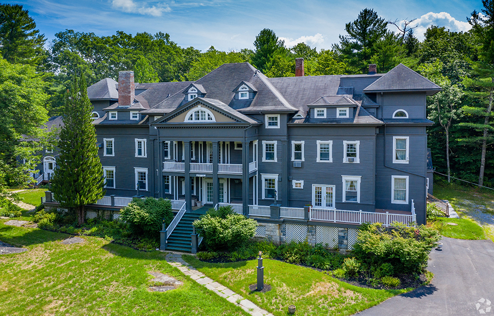
Galton of Houlihan Lawrence sells 15,800 s/f Wake Robin Inn for $3.5m
Lakeville, CT Houlihan Lawrence Commercial, a division of Houlihan Lawrence, a real estate firm serving Connecticut and New York City’s northern suburbs, has brokered the sale for $3.5 million of the Wake Robin Inn, a 15,800 s/f historic inn located on 11.52 acres at 106 Sharon Rd.